Purpose, scope and objectives of the BDA
The main technical role of the BDA is to identify, quantify, and set priorities for environmental problems that are transboundary in nature. In particular, the BDA aims to
- Collect data and produce maps on a range of technical areas within the basins and catchments of the 3S sub-basin;
- Review the institutional and stakeholder setting in the 3S sub-basin countries;
- Identify and prioritise the transboundary problems in the 3S sub-basin;
- Gather and interpret information on the environmental impacts and socio-economic consequences of each problem; and
- Analyse the immediate, underlying, and root causes for each problem, and identify specific practices, sources, locations, and human activity sectors from which environmental degradation arises or threatens to arise.
The cross-cutting issues of IWRM, climate change adaptation, ecosystems services, poverty, livelihoods and gender are integrated throughout all four processes. The spatial outputs of the BDA are being integrated into the 3S Basin Atlas and inform the joint priorities and proposed transboundary measures for the Joint Project. This framework approach is presented bellow.
3S Joint Project framework approach, including where the BDA fits in the step process (yellow box)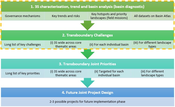
The BDA is intended for use and application by government agencies, river basin planners, provincial development authorities, city planners, civil society organisations and development partners. It is an essential initial foundational assessment in design of the comprehensive 3S Joint Project and to inform other development projects in the sub-basin.
Basin Diagnostic Analysis methodology
The Joint Project aims to assess the current state of water resources and climate change in the 3S, and opportunities for ecosystem scale interventions for transboundary cooperation on sustainable water resource management and climate change adaptation.
As part of the Joint Project preparatory process, the BDA focuses on the identification of at-risk watersheds, infrastructure, and livelihoods in need of improved resilience and hotspots for ecosystem degradation, flood and drought.
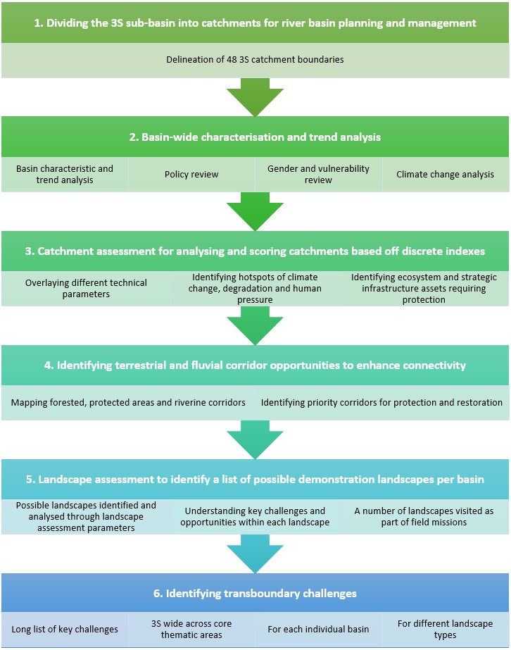
As part of the characterisation and prioritisation process under the 3S sub-basin assessment, five parallel processes are followed (Figure 3):
- A 3S and basin by basin analysis to provide all the spatial information and layers for the characterisation and trends of the three basins, leading to basin profiles. This also includes the identification and delineation of the 3S sub-basin and catchment boundaries, trend analysis, gender and vulnerability analysis, hydrological modelling, and climate change analysis.
- A catchment assessment based on multicriteria analysis leading to the identification of (i) hot spots of degradation and human pressure, (ii) climate change hotspots, (iii) remaining ecosystem assets requiring protection and (iv) strategic infrastructure assets at risk from development scenarios, ecosystem degradation, climate change and extreme events.
- A 3S wide analysis to identify terrestrial and freshwater bio-corridor opportunities to enhance the connectivity between and within aquatic and terrestrial ecosystems.
- A landscape assessment using secondary data, satellite images, key environmental and socio-economic parameters, and field consultations to identify five degraded landscapes in each of the three basins which are high priority for restoration and landscape management.
Availability of data and information (and data sources)
Data has been collected and analysed on areas such as hydrology, natural resources, biodiversity, land use, flood and drought, climate change projections and socio-economic status and trends. Secondary information has been collected on spatial, sectoral, and provincial plans, as well as existing and planned development projects, relevant to the 3S Joint Project.
A detailed data collection and acquisition plan was developed, which provided an overview of the data requirements, a description and rationale for each dataset and the relevant agency responsible for providing the data. Data requests from the PMU have been distributed to national line agencies via the National Mekong Committees (NMCs), supported by the national consultants. NMCs and line agencies have exchanged all information necessary for the activities, outputs, and effective functioning of the 3S Joint Project under this arrangement.
Important factors shaping the methodological scope for this initial preparatory phase of the 3S Joint Project include:
- The landscape assessment is identifying a list of priority landscapes and adaptation options for different landscape types (e.g. rivers, wetlands, reservoirs, forests, agricultural landscapes, protected areas, and urban areas) which will inform the design of the Joint Project;
- Climate change will have a very significant influence on water resources and natural and social systems in the 3S. Fresh climate change modelling is being conducted based on the latest Intergovernmental Panel on Climate Change (IPCC) 6 global projections;
- All hydrological and sedimentological information for the 3S is derived from existing sources, such as relevant online decision support systems held by CNMC and VNMC;
- Primary data has been collected at selected priority landscapes as part of the field mission to Cambodia and Lao PDR and will be collected a planned field mission to Vietnam. No primary field-based data collection has been undertaken for the overall 3S sub-basin;
- The Joint Project has relied on open-source and accessible secondary desk-based data and information with significant input from the PMU and national stakeholders.
Dividing the 3S sub-basin into catchments for the BDA
As a first stage in the BDA, a 3S catchment boundary identification and delineation process has been conducted. It has enabled the aggregation of 48 catchments of an appropriate size and number to conduct the catchment analysis in this study. As a first step, 79 catchments were defined as follows:
- 32 catchments in the Sekong with a total area of 28,453 km2 and average size of 889 km2 (median = 643);
- 21 catchments in the Sesan with a total area of 18,465 km2 and average of 879 km2 (median = 774); and
- 26 catchments in Srepok with a total area of 30,666 km2 and average size of 1,179 km2 (median = 644).
Steps to aggregate the catchments for the purposes of the BDA were (i) less than 100 km2 were merged with adjacent catchments, along with 11 catchments under 200 km2, and (ii) the catchments were aggregated according to those delineated by the SWAT hydrological model into 48 catchments, (iii) further consolidated based on the existing MOWRAM Cambodia 3S4P DSS and national river basin planning documents, then (iv) fine-tuned against administrative boundaries (Figure 4).
The 48 catchments provide the foundation units for data gathering and analysis in this study.
The 48 3S catchments defined as the basis for the BDA
Technical assessment of characteristics and trends
A review of the existing characteristics and trends across the 3S sub-basin is being undertaken for core technical areas. This analysis is being supported by spatial mapping to show the spatial and temporal distributional changes over time. Technical areas assessed include:
- Geophysical, geology and soils – geology, soils, erosion risk;
- Hydrology and sediment dynamics – river networks, riverbank erosion, groundwater, water quality, sediment deposits and change;
- Land use and land cover – land use and land cover drivers, evolution and core areas of change;
- Agriculture and fisheries – drivers and trends in agricultural expansion, agricultural concession areas and fisheries loss;
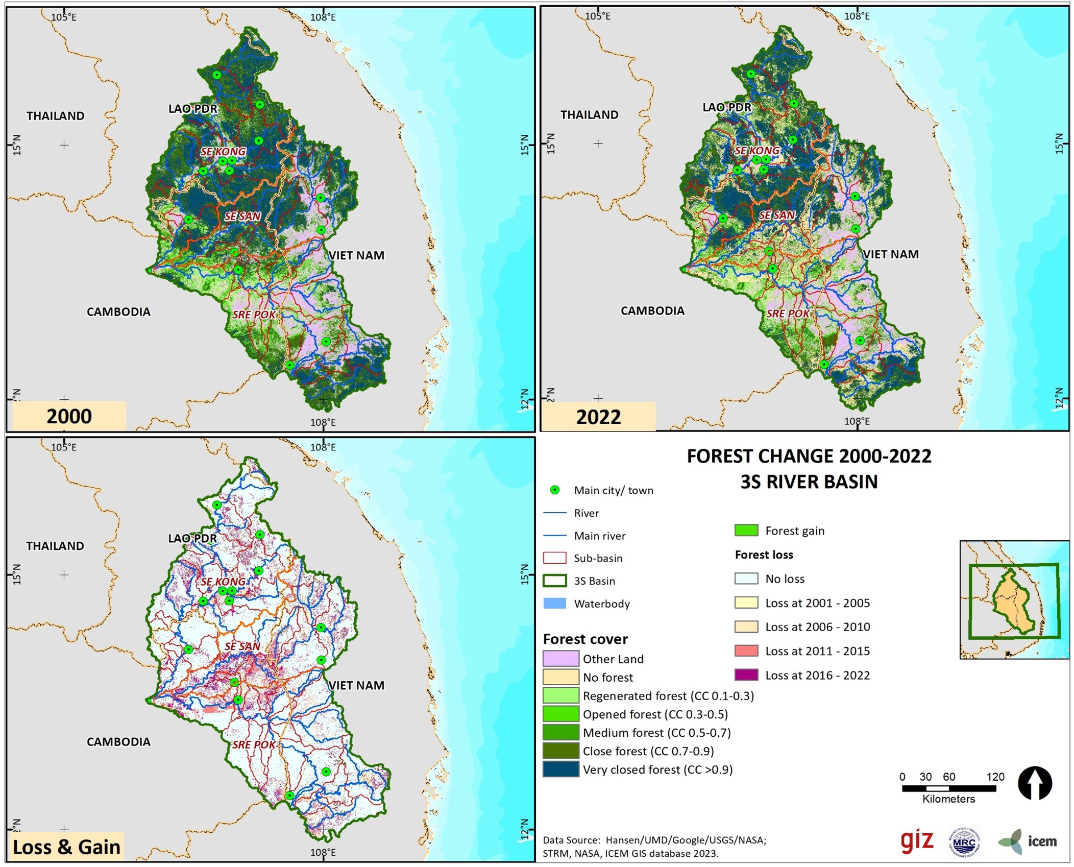
- Forests – forest types, changes in forest cover and loss (see Figure 5), deforestation threats;
- Biodiversity, ecological connectivity and ecosystem goods and services – terrestrial and aquatic biodiversity, protected areas and key biodiversity areas, bio-corridors, conservation threats and ecosystem services;
- Economic and socioeconomic trends – temporal and spatial development and socioeconomic changes across sectors, including mining, energy and hydropower;
- Infrastructure and assets – key strategic assets, including roads, transmission lines, reservoirs, irrigation systems, water supply and sanitation (WSS);
- Climate change – for temperature, rainfall and hazards (storms, landslides, forest fires, flood and drought, etc). Temperature and precipitation datasets are being developed based on the latest IPCC Sixth Assessment Report (AR6) scenarios (see Figure 6 for dry season examples).
Governace of water and natural resources
As part of the BDA, a review of relevant policies and institutions (past, present and future) in Cambodia, Lao PDR and Viet Nam, and their relevance for sustainable water resource management and climate change adaption in the 3S sub-basin, is being undertaken including:
- Relevant institutional structures;
- Stakeholder representation and arrangements;
- Policy, legislative and regulative frameworks;
- Joint master plans/action plans;
- Past and present projects and investments;
- National and regional gender and vulnerability policies;
- Governance challenges and gaps; and
- Trends and outlook.
Secondary information has been collected on spatial, sectoral and provincial plans, protocols, as well as existing and planned development projects (including on grey, hybrid and green infrastructure), relevant to the Joint Project. The Joint Project builds on past consultations and negotiations among 3S countries and seeks to help implement and maintain the momentum of the resulting plans of action, which have been formally adopted.
A Regional Inception Workshop was held in Hanoi on 17 August 2023, between the three project countries NMC’s and MRC-GIZ. The NMC’s presented an overview of their current work areas and relevant projects in the 3S, which has informed the policy and institutional review.
Governance structures and institutional setting
Governments in the four LMB countries are responding to the challenges of ecosystem restoration, and to flood and drought with increased commitment to integrated water resources management alongside the ongoing development of human engineered (grey) infrastructure at all scales. This action includes mandating and strengthening of river basin-scale planning, investments in ecosystem resilience, climate change adaptation and attention to cross-sectoral and multi-level cooperation. All four governments have made commitments to increase investment in conservation, to halt forest loss and to enhance watershed restoration as part of their participation in the biodiversity and climate change conventions conferences of parties and in response to the UN Decade on Ecosystem Restoration from 2021-2030.
Several significant recent and existing national and bi-lateral projects have been established for the 3S, which are being further aligned and explored, including:
- Mekong Integrated Water Resources Management Project (IWRM) – Phase III (2016-2022); and
- Enhancing Integrated Water Management and Climate Resilience in Vulnerable Urban Areas of the Mekong River Basin project (2021-2025).
Several existing protocols and plans developed for the 3S basins through MRC consultative mechanisms (Mekong IWRM Project) are being further aligned and explored, including:
- Transboundary Fisheries Management on the Mekong and Sekong Rivers in Cambodia and Lao PDR – Transboundary Fisheries Management Plan (MRC, 2019); and
- Joint Transboundary Action Plan in the Sesan and Srepok River Basin and the Mekong Delta of Cambodia and Viet Nam (MRC, 2019).
The existing national institutional capacity on water resource management and climate change for the three countries of the 3S sub-basin is being assessed, including for the institutional setting, (ii) legal and policy framework and (iii) relevant work by the NMCs. Relevant projects and investments on water resource management and climate change in the 3S sub-basins have been identified. This includes bilateral projects and initiatives. Governance challenges and trends associated with water and natural resources have also been assessed.
Past project challenges and successes (e.g. M-IWRMP – Mekong Integrated Water Resources Management Bilateral Projects (2013-2019) and the 9C-9T Joint Project (2019-2023)) have informed the developing of the proposed 3S Joint Project.
Stakeholder representation and participation
Relevant stakeholders in the 3S countries, basins and provinces have been identified as part of the catchment assessment. This will include both state and non-state actor stakeholder groups, including understanding key national and transboundary stakeholder interactions, challenges and trends on water resource management and climate change adaptation. The types of stakeholders, including how they are affected by and participate in natural resource management, vary from country to country.
Stakeholder groups may include:
- local resource users affected by climate change and variability (e.g., fisherfolk and farmers);
- stakeholders whose activities are resulting in soil deterioration loss of vegetative cover and forest and land degradation (e.g., local communities);
- internally displaced persons due to natural and/or human induced disasters and infrastructure projects;
- regulatory bodies involved in sustainable water resource management and river basin planning and regulation, including provincial and district agencies of water and environmental ministries (e.g. Ministry of Water Resources and Meteorology in Cambodia and Ministry of Natural Resources and Environment in Lao PDR and Viet Nam), in charge of environmental monitoring and protected areas such as Ramsar Wetlands, Wildlife Sanctuaries, National Biodiversity Conservation Areas, etc;
- private sector, such as hydropower companies, wind farms, exploration of ore, minerals and other deposits, mining, and concession farming;
- development partners implementing projects in the 3S sub-basins; and
- CSOs and NGOs involved in nature conservation, disaster and emergency response, and restoration activities.
Gender and vulnerability considerations
Promoting gender equity and social inclusion within project activities and outputs is crucial to IWRM and mitigation activities. Gender and social vulnerability are key considerations of the Joint Project. Vulnerable groups are most likely to be most impacted by, and least resilient to, ecosystem and water degradation, flood and drought and loss of fisheries and other natural resources. Vulnerable groups also include internally displaced persons due to natural and/or human induced disasters.
Relevant global and regional policy frameworks applicable for the 3S Joint Project are being reviewed, including national and MRC policy frameworks and standards in place on gender and vulnerability. A high-level gender sensitive and vulnerability analysis for the 3S sub-basin has been undertaken.
Major transboundary challenges
Identification of the priority transboundary problems
Water resource and climate related challenges have been identified for the 3S sub-basin, based on a review of secondary information, primary data collection and field missions, including:
- Transboundary urban flood risk and a lack of high-resolution flood risk maps;
- Flood risk impacts on agriculture and livelihoods;
- Riverbank erosion;
- Use of protected areas for hydropower development;
- Protected area encroachment by concession areas and other agricultural development;
- Forest loss and fragmentation due to land use change, including encroachment by concession areas and other agricultural development;
- Lateral barriers to fish migration, habitat fragmentation and fish stock reductions;
- Wetland encroachment and drought impacts on seasonal ponds;
- Limited water holding capacity of the landscape in lowlands;
- Agricultural water stress and over abstraction of groundwater;
- Uncoordinated and poorly assessed grey infrastructure development;
- Lack of transboundary data sharing, early warning and notification;
- Low density of water quantity and water quality monitoring network;
- Limited information on climate risk and vulnerabilities, including mapping as well as forward-looking, long-term climate change scenarios and foresight;
- Limited international peer-to-peer visits or exchanges as well as the capacity of provincial and district agencies to deal with emerging challenges in the 3S sub-basin;
- Sedimentation of lakes and reservoirs; and
- Pollution and degradation of waterways and waterbodies.
Application of a catchment assessment to analyse the priority challenges for the 3S sub-basin
A comprehensive catchment assessment has been conducted to identify hotspot areas within the 3S sub-basin for ecosystem degradation and flood and drought risk, to inform river basin planning and management, including addressing transboundary issues. Priorities are being identified based on spatial analysis, remote sensing, and ground truthing. The catchment assessment forms a core part of the 3S Joint Project methodology, as highlighted below.
Catchments that are significantly degraded or that contain valuable natural and human assets will be identified by assessing and ranking sub-catchments according to rehabilitation needs.
Seven composite indexes were developed for the catchment hotspot analysis, comprising several parameters, defined as follows:
| 1. Flood risk | Projected in 2050 (IPSL 4.5) | Average flood depth |
| Flood area > 0.5 m | ||
| 2. Drought risk | Projected in 2050 | Change in number of drought duration |
| 3. Erosion risk | Potential soil erosion (RUSLE) | |
| Erodability index (bedrock) | ||
| 4. Biodiversity risk | Protected areas | |
| Key biodiversity areas | ||
| Degree of Naturalness (2020) | ||
| Degree of Naturalness loss (2002 - 2020) | ||
| 5. Forest loss risk | Forest cover (Tree cover > 10%) in 2023 | |
| Forest loss (2001 - 2023) | ||
| 6. Climate risk | Change in precipitation in dry season (2050) | |
| Change in precipitation in wet season (2050) | ||
| Wettest month precipitation change (2050) | ||
| Change in annual temperature (2050) | ||
| 7. Human pressure | Population density (2020) | |
| Agricultural land | ||
| Plantations (2020) | ||
| Linear infrastructure | ||
| Built-up areas | ||
In addition to the hotspot parameters, six key composite indexes are proposed for the asset analysis, comprising the following parameters:
| 1. Terrestrial biodiversity | 1.1 Number of threatened species |
| 1.2 Native species richness | |
| 2. Aquatic biodiversity | 2.1 Number of threatened species |
| 2.2 Aquatic species richness | |
| 3. Fish species (with or without dams) | 3.1 Fish migration |
| 3.2 Endemic fish species | |
| 4. Socio-cultural characteristics | 4.1 Ethnic diversity |
| 4.2 Urban/rural ratio | |
| 4.3 Population (within 5km of river) | |
| 4.4 Cultural heritage, tourism and recreational sites | |
| 5. Strategic infrastructure value | 5.1 Infrastructure density |
| 5.2 Reservoirs and open water | |
| 6. Forests | 6.1 Forest landscape integrity |
| 6.2 Endangered tree species richness |
Connectivity is being assessed by terrestrial and freshwater ecosystems. A 3S sub-basin wide analysis is being undertaken to identify terrestrial corridor opportunities to enhance the connectivity between ecosystems – for example between remaining forest patches and protected areas – and along disrupted drainage corridors – the aim being to enhance ecosystem services and lead to biodiversity net gain.
The 3S basin connectivity is being assessed as part of the BDA, using the following approach:
- Terrestrial connectivity: Terrestrial connectivity assessed by measuring land use and distances between recognised forest ecosystems, or the fragmentation within protected areas and along riparian corridors, by the construction of dams, reservoirs, roads and transmission lines.
- Fluvial connectivity: Freshwater connectivity would use and adapt the methodology developed for assessing the free-flowing rivers of the World, considering the degree of fragmentation of the river ecosystems, degree of regulation in the flows and sediment trapping. This will need to be updated to include new hydropower dams and other infrastructure development.
This analysis will help to identify key areas of concern, or ‘hotspots’, for basin fragmentation, as well as opportunities for increasing connectivity, including the preservation and/or establishment of nodes, stepping stones, corridors and entire landscapes.
To support the development of the indexes, the following spatial data will be explored to provide the GIS layers for these processes. These include (i) biophysical parameters; (ii) strategic infrastructure; and (iii) social parameters.
Transboundary challenges for the 3S sub-basin
A key step in the BDA process is to identify the transboundary problems in the 3S sub-basin. Transboundary challenges have been identified based on secondary information, discussions during workshops, NWGs and field missions.
Priority transboundary problems are identified based on the nature and severity of their transboundary impact, including the underlying and root causes, and potential environmental and socioeconomic impacts.